
2021 Aston Martin DBX Navigation User Manual
The state-of-the-art navigation system of the 2021 Aston Martin DBX skillfully combines luxury and technology. The DBX’s navigation system provides precise direction and easy-to-use controls to improve the driving experience on every trip. Drivers may input destinations, receive real-time traffic information, and discover areas of interest along the road with ease thanks to an intuitive UI. The high-resolution display of the system ensures optimal vision and route planning by providing detailed and clear maps. The DBX navigation system places a premium on efficiency and convenience and is outfitted with cutting-edge technologies including voice command capabilities and predictive traffic routing. Whether traveling by car or through cities, this technology improves overall driving comfort and performs dependably. Experience unmatched creativity and sophistication with the 2021 Aston Martin DBX’s navigation system, which is redefining the way automotive technology is integrated.
Navigation
Safety Information
Warning: Failure to avoid the following potentially hazardous situations could result in an accident or collision resulting in death or serious injury.
Warning: Always use your best judgement, and operate the vehicle in a safe manner. Do not become distracted by the navigation system while driving, and always be fully aware of all driving conditions. Minimise the amount of time spent viewing the screen while driving and use voice prompts when possible.
Warning: Do not input destinations, change settings, or access any functions requiring prolonged use of the navigation system controls while driving. Bring the vehicle to a halt in a safe and legal manner before attempting such operations.
Warning: When navigating, carefully compare information shown on the screen to all available navigation sources, including road signs, road closures, road conditions, traffic congestion, weather conditions, and other factors that may affect safety while driving. For safety, always resolve any discrepancies before continuing navigation, and defer to posted road signs and road conditions.
Warning: The navigation software is designed to provide route suggestions. It is not a replacement for driver attentiveness and good judgement. Do not follow route suggestions if they suggest an unsafe or illegal manoeuvre or would place the vehicle in an unsafe situation.
Using The Map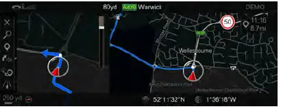
Some functions in the navigation system allow the user to find or select locations by scrolling the map directly.
Move the cursor by pushing the CONTROL DIAL in the chosen direction. Rotate the CONTROL DIAL clockwise to zoom out and counter-clockwise to zoom in. Once you have chosen a location, press ENTER. This will then select the location or give more information depending on the function.
Aston Martin DBX Navigation Menu Owner’s Manual
Car Navigation Tips
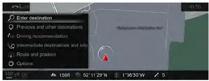
From the navigation menu select from the following options:
- Cancel Route Guidance:
Cancels currently selected route. (Only shown when a route is set). - Enter Destination:
Opens the Enter Destination menus. - Previous and other destinations:
Opens the Previous and other destinations menus. - Driving recommendation:
Set if audible navigation announcements are given. - Intermediate destinations and info:
Opens the Intermediate destinations and info menu. - Route and Position:
Opens the Route and Position menu. - Options:
Opens the navigation Options menu.
Enter Destination
The navigation does not automatically add spaces in address line items such as postcodes. Select to search for a destination.
A destination can be searched in two ways:
- Enter the address or POI
- Enter the address step-by-step Enter the address or POI
Search a location without having to enter the full name. Once a partial location has been entered, the navigation system will suggest destinations.
These suggestions can include:
- Addresses.
- POIs.
- POI categories, such as fuel station.
- List Search.
Town and street names can be searched for at the same time by separating with. For example, LON REGE can find Regent Street in London.
Enter address step-by-step
Enter information in the steps to find a destination. As more criteria are entered, the suggestions are filtered down.
Available criteria are:
- City or postcode
- Street
- House No.
- POI
Previous and Other Destinations
- Previous destination:
Opens the previous destination menu to select destinations that have been used before. - From global favourites:
Select to open a list of saved favorite locations. - POIs:
Open the Points of Interest menu to select landmarks, facilities etc. - Contacts:
Search from a list of contacts on the contact list with available addresses. - Geo-coordinates:
Select to enter a destination using geo-coordinates.
Previous Destination
Search from a list of previously entered addresses. Scroll through the list of available locations and push the CONTROL DIAL sideways to view the following options:
- Save as global favourite:
Adds a selected address to the list of global favourites. - Save as “Home” address:
Adds the selected address as the home address. - Save as “Work” address:
Adds selected address as a work address. - Delete:
Delete the selected destination. - Delete All:
Delete all previous destinations. - Map:
Shows the destination on the map. - Details:
View a list of details for that destination.
POIs
Select a POI category from a list of popular categories. Select All categories to open a full list of available POI categories. Once a category has been selected, select a location from:
- In the vicinity:
Choose a point of interest near your current location. - Near Destination:
Choose a point of interest near your destination. - Along the Route:
Choose a point of interest that is in the vicinity of the chosen route.
<Near Destination> and <Along the Route> are only available if a route is set.
Intermediate Destinations and Info
A maximum of 4 intermediate destinations can be added to a journey.
Search to add an intermediate destination to your route. To add a new intermediate destination, scroll to an empty slot in the route list and press ENTER where Add new is displayed. Once an intermediate destination has been added, select it in the list, and push the CONTROL DIAL sideways to view the following options:
- Move:
Move what slot in the list the selected item is set to. - Delete:
Delete the selected intermediate destination. - Map:
Shows the destination on the map.
Route and Position
- Alternative Route:
Shows 2 available routes. - Avoid Options:
Opens the Avoid Options menu. - Route Settings:
Set whether the proposed routes are set as Eco route, Fast route or Short route.
Traffic avoidance options are given as Avoid traffic jam automatically and Ask before changing route to avoid traffic jam. - Compass:
The compass shows direction, geo-coordinates and altitude. The number of satellite signals are also shown. - Qibla:
Shows a compass giving the direction of Mecca for prayer. The number of satellite signals are also shown.
Avoid Options
Select from the following options:
- Areas:
Select an area for route calculation to avoid. Choose a location from: - Using Map
- Address Entry
- Previous location
If an area has already been set, push the CONTROL DIAL to the left to bring up the following options: - Edit:
Show and edit the location of the area to be avoided. - Delete:
Delete the current saved area. - Delete All:
Delete all saved areas. - Map:
Show the selected area on the map. - Motorways
- Ferries
- Motorail
- Tunnels
- Unpaved Roads
- Use Vignette Roads:
Select a country on the route or choose to select all countries. - Use Toll Roads:
Select from Cash, Electronic billing or Off.
Options
- Map Menu:
Opens a crossbar menu of map display settings. - Map Content:
Opens the Map content menu. - Announcements:
Open the Announcements menu. - Text Information:
Open to choose what text is shown on the bottom of the navigation screen. Select from Current street, Geo-coordinates, Climate control or None. - Auto zoom:
Set whether navigation automatically zooms in on a location. - Next intersecting street:
Shows the next crossroad or joining street when route guidance is not active. - Reserve Fuel Level:
Set to automatically search for a fuel station when the fuel tank reserve level is reached. - Map Version:
Shows the map software data version.
Map Content
Choose from the following map content options:
- POI Symbols on Map
- Standard:
Shows default point of interest symbols. - User-defined:
Select custom POI symbols for the available categories. - None:
Remove point-of-interest symbols from the map display. - Satellite Map:
Select if the map is shown as a satellite image. - Range:
Show the vehicle range available with the current fuel level. - Traffic Delay:
Select if traffic delays of more than 1 minute are shown in the map.
Announcements
Choose from the following system settings:
- Announce traffic warnings:
Set to announce when there is traffic on the route. - Driving safety voice announcements:
Set to announce when safety warnings are given on the route. - Announce street names:
Set to announce street names during changes of direction (Market Specific).
FAQ’s
The 2021 Aston Martin DBX features a sophisticated Navigation System that utilizes GPS technology to provide accurate and real-time navigation information. The system typically includes a touchscreen interface and voice commands for user-friendly operation.
The Navigation System in the 2021 Aston Martin DBX typically includes features such as turn-by-turn directions, points of interest, real-time traffic updates, and route optimization. It may also integrate with other vehicle systems for enhanced functionality.
Aston Martin aims to design user-friendly interfaces, and the Navigation System in the 2021 DBX should be intuitive for drivers. The touchscreen display and voice commands contribute to ease of use.
Voice recognition is a common feature in modern Navigation Systems. The 2021 Aston Martin DBX likely includes voice recognition capabilities, allowing drivers to control navigation functions without taking their hands off the wheel.
Safety regulations typically restrict certain functions while driving. The 2021 Aston Martin DBX Navigation System may have safety features that limit or lock certain inputs while the vehicle is in motion.
Many modern Navigation Systems, including the one in the 2021 Aston Martin DBX, are equipped with real-time traffic updates. This feature helps drivers navigate around traffic jams and choose the most efficient routes.
Personalization options are common in vehicle infotainment systems. The 2021 Aston Martin DBX Navigation System may offer customization features, allowing drivers to adjust the display settings according to their preferences.
The Navigation System in the 2021 Aston Martin DBX typically includes a points-of-interest (POI) database, helping drivers locate nearby amenities such as restaurants, gas stations, and other attractions.
The GPS system in the 2021 Aston Martin DBX Navigation System is designed to provide accurate location information. However, occasional discrepancies may occur, and software updates can help maintain optimal accuracy.
Many modern vehicles support smartphone integration. The 2021 Aston Martin DBX may allow integration with smartphones, enabling features like Apple CarPlay or Android Auto for enhanced connectivity and functionality.
The Navigation System in the 2021 Aston Martin DBX typically offers alternative route options, allowing drivers to choose different paths based on preferences or real-time traffic conditions.
Useful Links
View Full PDF: 2021 Aston Martin DBX User Manual | Auto User Guide